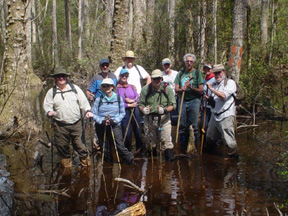
 This part of the Florida Trail passes through the eastern part of this 557,000 acre Apalachicola National Forest through a unique natural feature, Bradwell Bay. The term “bay” refers to a broad stretch of low land between hills. Bradwell Bay is a huge, shallow saucer containing a vast stretch of titi thicket (buckwheat tree) in the center, with occasional clusters of blackgum and other hardwoods, surrounded by higher ground with typical pine and palmetto sandy terrain, Bradwell Bay was named for a hunter who was once lost for days in the vast, trackless titi thicket.
This wilderness is very similar to the area just to the south called “Tate’s Hell.” If the precautions required are taken, bays are interesting and beautiful places to hike. The forest sections of this trail contrast with the bays and have a large variety of the plants and animals typical of the pine and palmetto forest. There are orchids, lilies, bladderworts and pitcher plants in addition to oak, maple and gum trees. Animals of the forest include the red-cockaded woodpecker, osprey and alligator. There are also bald eagles, sandhill cranes, turkeys, bears and panthers.  Bee hives filled with titi blossom honey can be seen at the edge of the forest. In the forest look for the scarred pine trees and clay pots which are relics of the turpentine industry. Earthworms, an unusual product of this forest, are harvest by “grunting.” Earthworms are called to the surface by driving a wooden stake into the ground then rubbing the stake with a heavy piece or iron such as a section of steel rail from a railroad scrap pile, to make a “grunting” sound. The young pine plantations of this or any working forest are good places to look for wildlife, because the younger trees produce a higher yield of “mast” (forage foods) per acre than do older trees. As an interesting side trip before or after your hike, go to the St. Marks lighthouse and the national Wildlife Refuge, just a few miles away on the Gulf of Mexico.
Type of Hiking
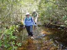
The trail goes through swampy forest. Hikers may have to wade after a heavy rain. The water may be waist deep in the Bradwell Bay Wilderness during high water.
Location
The east part of the Apalachicola National Forest is located southwest of Tallahassee. The east terminus of this Florida Trail segment is on US 319, 1.1 miles west of Medart. The west terminus is one mile west of CR 375 on FH13 (CR 368). A side trail (blue-blazed) leads to the historic Langston Homestead. Hikers may bypass about a mile of private land on CR 375 and FH 13 to continue on to the west section of the Florida Trail, which starts at Porter Lake Campground. Carry your FTA membership card.
Maps
CLICK HERE for map and directions to trailheads in the ANF.
CLICK HERE to purchase a map of this section from FTA.
CLICK HERE for a Summary Sheet with map, mileage points and other information for hiking this section.
For current advisories and changes to the maps, see the Florida Trail website.
Parking
Park at either terminus at your own risk. See below for locations of trailheads in the ANF.
Conveniences
Supplies: Sopchoppy , Medart
Mail: Sopchoppy 32358
Lodging: Wildwood Inn, US 98, Medart
Public Campgrounds: Camel Lake, Hickory Landing, Porter Lake, Whitehead Lake, Wood Lake and Wright Lake: all in the National Forest
Assistance
Wakulla County Sheriff: 850-926-7171
Wakulla District Ranger Office: 850-926-3561
Precautions
Wear safety orange if you hike during the general hunting season. Crossing the Bradwell Bay Wilderness through thick titi shrubs requires maps (both FT and USFS) and a compass. Bridges across Sopchoppy River and Monkey Creek may not be visible in high water. When the Sopchoppy River is in flood stage (28 feet), hiking the trail along it becomes impossible/dangerous; check THIS SITE for current water level. Check with the USDA Forest Service before hiking through Bradwell Bay to verify water levels.
Click here for trailheads map and directions.
For current advisories and changes to the maps, see the Florida Trail website.
